It certainly has been a crazy year when it comes to weather. 2018 came in like a lion but did not go out like a lamb.
First on the list of our big events in 2018 was the frigid temperatures kicking off the New Year. You may not remember this, but on Jan. 1 and 2, the Miami Valley experienced below zero temperatures twice. On Jan. 2 the Dayton International Airport fell to 13 below zero, smashing the previous record daily low temperature set in 1898. The coldest spot that morning belonged to Germantown, reaching a bitter 18 degrees below zero.
The forecast was the void of any real significant weather until the spring. It was a juxtaposition that the first day of spring arrived on March 20, but on March 21 several rounds of snow fell across the region, bringing anywhere from 2 to almost 7 inches of snow. Unfortunately the snow occurred during the morning commute, leading to slippery roads and dozens of slide offs.
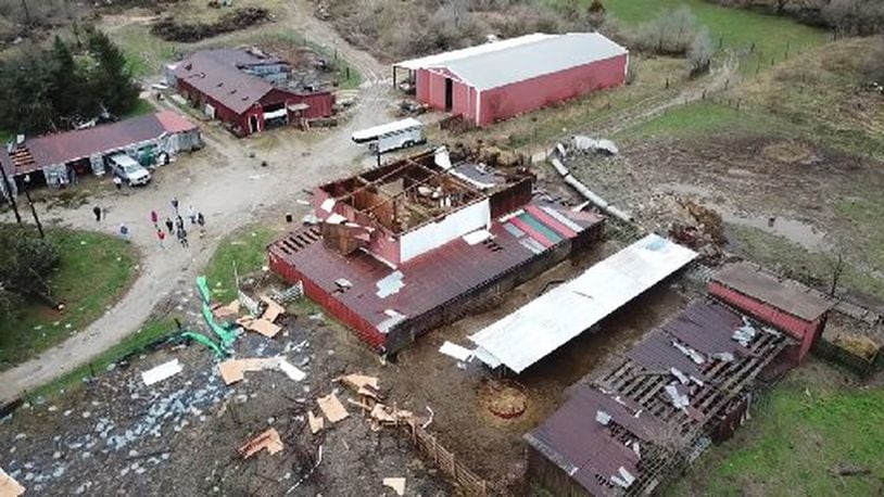
April is deemed the first month of severe weather season and that’s exactly what happened in southwest Ohio. On the 44th anniversary of the April 3, 1974, Xenia tornado, our team of meteorologists were tracking strong storms that would produce several tornadoes. Storm damage surveys showed four tornadoes occurred that day. Three EF-1 twisters, one in Xenia, one near Selma in Clark County and another in Grove City. The fourth was an EF-0 near London.
Our next weather event is not typical to our region but is possible. Tropical systems are native to coastal regions, but sometimes we can feel the impacts here at home. This year was a prime example as the remnants of Hurricane Gordan brought flooding rain to the area in early September. Two to almost 7 inches of rain soaked the area from Cincinnati to Dayton. One of the highest totals reported was in Kettering, with 6.75 inches of rain.
Rounding out the list of our biggest events of 2018 was the ice storm in mid-November.
The month started out colder than normal. These chilly temperatures during the first two weeks helped to cool the ground just enough to lead to an icy mess on Nov. 15. As warm, wet air pushed over the Miami Valley, freezing rain developed. More than quarter of an inch of ice accumulated in many spots, coating trees, power lines, cars and sidewalks. Widespread power outages were reported from falling branches and downed power lines.
Living in this part of the country can be eventful as our look back at 2018 has proven. And next year looks to be no different.
We start the year smack dab in the middle of winter. Our winter outlook has been standing up to the data thus far and appears on track. January has equal chances of being warmer and colder than average with near normal precipitation. Meaning a typical January forecast is to be expected with quick blasts of cold air and snow, followed by some relief. February has a better chance of being colder and snowier with bigger snow totals. After that, we will just have to wait and see.
Until then, Happy New Year! Stay safe and be weather aware because the weather is always changing in Ohio.
