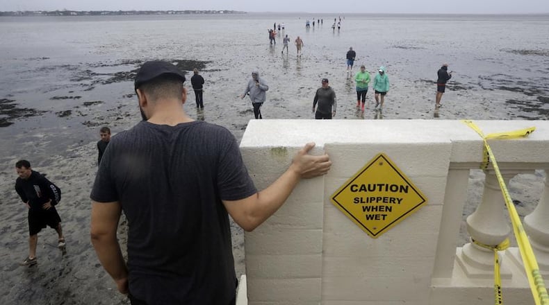
The official peak of hurricane season in the United States was Sept. 10 and this year will go down as having two record-breaking storms within two weeks of each other. With the help of social media, it is likely you saw pictures of scenes you may have never seen before – such as the ocean appearing to disappear from inlets in the Bahamas and in Tampa.
RELATED: 10 photos that tell the story of Hurricane Irma’s impact
But first, let’s look at Hurricane Harvey, which was the first major hurricane to hit the United States since Hurricane Wilma in 2005. Ironically, Hurricane Wilma was the last major hurricane to hit Florida until Irma arrived over the weekend.
The intensification of Harvey occurred incredibly rapidly, going from a tropical depression to a category 4 hurricane in a near-record pace, just over 50 hours. The reason? The temperature of the water in the Gulf of Mexico is running nearly 3 degrees above normal. This added fuel to the storm.
Harvey broke the record for amount of rainfall from a tropical storm in the continental United Stated with nearly 52 inches of rain reported near the town of Highlands, Texas. Meteorologists had to literally create to color-tables on their weather graphics just so we could forecast the amount of rain this storm produced. While the incredible amount of rain was the primary reason for the flooding in Texas and the Houston area, it is important to note that the sea-level has risen about 6 inches in this area over the last 20 years alone.
»WEATHER: Get the latest Storm Center 7 forecast
We watched another record-breaking storm blast through the Caribbean last week, then into Cuba and then Florida and Georgia over the weekend. Hurricane Irma broke several records including being the first storm to reach category 5 strength while still being over the middle of the Atlantic Ocean.
Other storms have not gotten that strong until reaching the relatively warmer waters of the Caribbean Sea or Gulf of Mexico since records have been kept. Also, Hurricane Irma not only became a category 5 storm sooner, but also maintained that strength for three consecutive days, the longest ever on the planet in the satellite era of monitoring storms.
Irma started as a cluster of storms that moved off the west coast of Africa over two weeks ago and traveled across the Atlantic Ocean and Caribbean Sea before making landfall in Cuba on Sept. 9 and Florida on Sept. 10.
Perhaps the most incredible images captured was from Long Island, Bahamas and Tampa Bay, Florida as people reported the ocean disappearing from the shore. The water was basically sucked out of these shallow inlets due to very strong off-shore winds and the extremely low pressure created by the center of Hurricane Irma. This low pressure causes the water to bulge up under the center of the storm. This bulge is what creates the sudden increase in water levels or storm surge that occurs once the eye moves on shore. This unusual scene of people walking out into Tampa Bay panicked local officials as once the storm moved closer, the water would come ushering back into the bay, and then rising out of the banks. This prompted emergency flash flood warnings to be issued.
While the remnants of Irma continue to weaken, meteorologists continue to look out over the ocean to see what will happen with another storm named Jose, which is forecast to meander over the central Atlantic. Ocean water temperatures remain incredibly warm thanks to our changing climate. If these waters remain this way, it is likely we will see more record-breaking, wild storms in our future. Stay tuned.
Eric Elwell is WHIO StormCenter 7 Chief Meteorologist. Contact him at eric.elwell@coxinc.com or follow him on Facebook and Twitter.
About the Author
