WEATHER: Get the latest Storm Center 7 forecast
What can a deeper dive into the numbers tell us about the upcoming fall and winter?
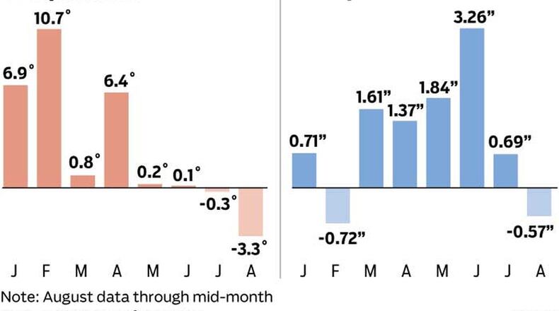
Let’s take a look at last winter which wound up being unusually warm. January and February in the Miami Valley were between 7 to 10 degrees above normal. The warm trend continued into early spring as temperatures topped 6 degrees above normal in April. But in May, the skies opened up with significant rainfall. With all the rain, temperatures began to drop below what is typical for that time of year.It seems that as the summer has progressed, we’ve seen a decline in the temperatures. We are now in mid-August and we are running over 3 degrees below normal for the month.
RELATED: Soaking rains keeping summer heat in check, for now
So, what is the reason for the change in our pattern since the winter? Well, the answer may lie in the Pacific Ocean. You may remember the term El Nino which was a major influence on our weather pattern late last year and the beginning of this year. El Nino occurs when there is warming of the ocean surface, or above-average sea surface temperatures in the central and eastern tropical Pacific Ocean. This warming impacts the jet-stream pattern and thus the weather across North America. This pattern typically leads to a warmer than usual winter for the Ohio Valley. But now, there is no evidence of El Nino in the Pacific Ocean, which makes forecasting the upcoming seasons a bit more complicated.
MORE: Solar Eclipse 2017: Read this before looking at the sun
What we can do is look at the overall trend. That trend shows temperatures and precipitation departing from the normal and this may be a bit disturbing if you don’t like winter.
Notice the temperature trend from earlier in the year through the summer. You can see where we went from a warm and dry winter to a cooler but wet late spring and summer. August has seen temperatures well below average so far, but that may be about to change. According to data released by the Climate Prediction Center, precipitation is expected to return to more normal levels for this time of year. With that, temperatures are expected to rebound closer to what they should be for this time of year. Summer does not appear to be over yet.
It is hard to know whether the upcoming warm-up is just a small bump in a longer term colder trend we’ve been experiencing since late spring, or if the pattern will turn around to be warmer than normal the rest of the year as has been expected by most forecasters. As far as the coming winter projections, we will be reviewing what is called analog data in the days ahead. This is the process of looking at data of years in the past that have had similar weather and temperature patterns to our current year - and using that data to predict what may be coming.
For now though, it is just too early to know for sure how the pattern may evolve as we move into the typically colder months, so stay tuned!
Eric Elwell is WHIO StormCenter 7 Chief Meteorologist. Contact him at eric.elwell@coxinc.com or follow him on Facebook and Twitter.
About the Author
