This major temperature swing occurred thanks to a blocking weather pattern that developed over Greenland late in March and lasted through most of April. This pattern forced the jet stream to stay unusually far south through the majority of the month. Cold, Canadian air kept flowed into the Miami Valley bringing with it bouts of snow late into the month.
RELATED: 5 shopping trends expected to completely reshape area malls by 2023
The major pattern change occurred the last few days of April as the block across Greenland released, allowing the jet stream to return to a more normal, typical flow pattern around the arctic circle. As this Greenland block was breaking down, an unusually strong area of high pressure developed off the Mid-Atlantic coastline. Since the wind typically flows clockwise around high pressure, southerly winds began to become dominate across the eastern half of the country.
This allowed winter to almost turn to summer across the Miami Valley.
Instead of temperatures climbing into the 60s and 70s, we saw readings soar into the 80s and 90s. On May 27 and May 28, the temperature in Dayton reached 90 degrees for the first time in over 240 days - and was the first consecutive 90-degree days since September of 2016. That is pretty impressive considering summer was still a month away at the time.
The big question a lot of people have been asking, and assuming, is whether we will have a hot summer. The answer may not be as clear-cut as one might think.
The weather pattern seems to be setting up to be more active as we head into the summer. This means better chances for rain and storms. When the weather is more active, this can have a way to prevent major heat waves from occurring. It is very difficult to heat surface temperatures above 90 degrees when the top layer or two of soil contains quite a bit of moisture. Typically, our hotter days occur when we have a lack of rainfall. Not surprisingly, May turned out of have below normal levels of precipitation.
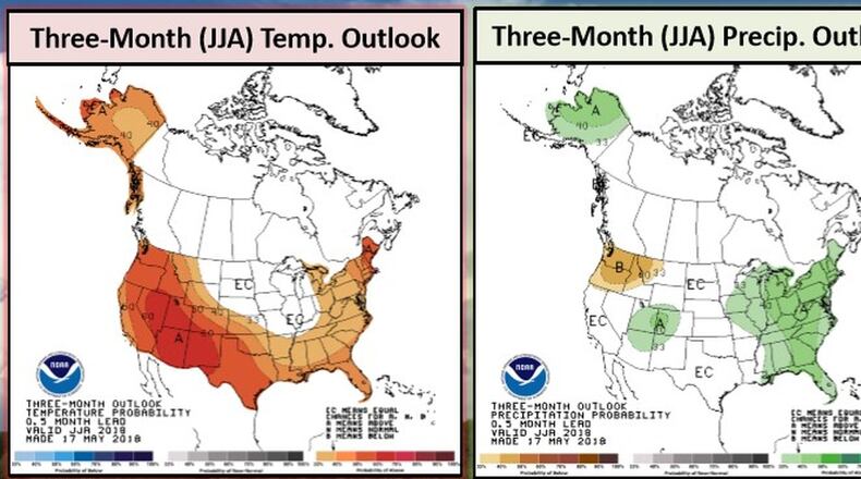
The latest summer outlook from the Climate Prediction Center (CPC) is calling for near to slightly above normal temperatures through the summer. However, the CPC is also calling for above average precipitation.
With a more active weather pattern, this may keep us from having too many 90 degree days. However, if we start to dry out, expect the temperature to climb. If the pattern does stay active, this may increase our risk for severe storms this summer.
It certainly looks like we’ll have plenty to look out for over the coming few months.
FIVE FAST READS
• Algae plaguing Ohio lakes could force Kasich to take executive action
• Ohio colleges taking steps to avoid unchecked sex abuse cases
• PHOTOS: Victorian farmhouse with wine cellar, party barn on sale in Troy
• Local college took on #MeToo decades before a movement went mainstream
• Longaberger Co. going out of business: What it means for your baskets
About the Author
